NOAA JPSS Visible Infrared Imaging Radiometer Suite (VIIRS) Aerosol Optical Depth and Aerosol Particle Size Distribution Environmental Data Record (EDR) from NDE
JPSS-AOD-NDE
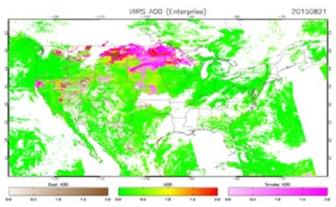 Example of Suomi NPP VIIRS AOD (Enterprise) with global coverage from August 21, 2015.
This Environmental Data Record (EDR) provides aerosol optical depth (AOD) and particle size from the Visible Infrared Imaging Radiometer Suite (VIIRS) instrument onboard Suomi-NPP, NOAA-20, and NOAA-21. The retrieval algorithm is based on a legacy product originally developed for the Moderate Resolution Imaging Spectroradiometer (MODIS) sensor but is adapted and improved upon for use by VIIRS. The AOD product consists of vertically-integrated total column extinction at mid-visible 0.55 micron and for a range of wavelengths from 0.412 to 2.25 micron. The spatial resolution is 750 meters at nadir and the temporal resolution is daily except under cloudy or unfavorable conditions. VIIRS AOD data is distributed by the Comprehensive Large-Array Stewardship System (CLASS) as single 86-second granules in the NetCDF-4 format with metadata attributes included. Note: the Aerosol Particle Size Parameter (APSP) is included only over ocean and is reported as Ångström exponent.
- Cite as: Kondragunta, Shobha, Laszlo, Istavan, Ma, Liqun, JPSS Program Office (2017): NOAA JPSS Visible Infrared Imaging Radiometer Suite (VIIRS) Aerosol Optical Depth and Aerosol Particle Size Distribution Environmental Data Record (EDR) from NDE. [indicate subset used]. NOAA National Centers for Environmental Information. doi:10.7289/V5319T4H. [access date].
- doi:10.7289/V5319T4H
- gov.noaa.ncdc:C01446
- gov.noaa.class:JPSS_GRAN
C01446
| Download Data |
|
| Order Data |
|
| Distribution Formats |
|
| Distributor | Customer Engagement Branch
DOC/NOAA/NESDIS/NCEI > National Centers for Environmental Information, NESDIS, NOAA, U.S. Department of Commerce 1-828-271-4800 ncei.orders@noaa.gov |
| Dataset Point of Contact | Customer Engagement Branch
DOC/NOAA/NESDIS/NCEI > National Centers for Environmental Information, NESDIS, NOAA, U.S. Department of Commerce 1-828-271-4800 ncei.orders@noaa.gov |
| Time Period | 2017-07-06 to Present (time interval: 24-hour) |
| Spatial Reference System | urn:ogc:def:crs:EPSG::4326 |
| Spatial Bounding Box Coordinates |
N: 90.0
S: -90.0
E: 180.0
W: -180.0
|
| Spatial Coverage Map | |
| General Documentation |
|
| Processing Documents |
|
| Associated Resources |
|
| Publication Dates |
|
| Data Presentation Form | Digital image
|
| Dataset Progress Status | Ongoing - data is continually being updated |
| Data Update Frequency | Continual |
| Purpose | The S-NPP VIIRS aerosol products are designed for use by the climate, air quality, research, applied, private, governmental, and military communities for the purpose of research, forecasts, communication, and policy decisions. |
| Use Limitations |
|
| Dataset Citation |
|
| Cited Authors |
|
| Principal Investigators |
|
| Resource Providers |
|
| Publishers |
|
| Theme keywords | Global Change Master Directory (GCMD) Science Keywords
|
| Data Center keywords | Global Change Master Directory (GCMD) Data Center Keywords
|
| Platform keywords | Global Change Master Directory (GCMD) Platform Keywords
|
| Instrument keywords | Global Change Master Directory (GCMD) Instrument Keywords
|
| Place keywords | Global Change Master Directory (GCMD) Location Keywords
|
| Project keywords | Global Change Master Directory (GCMD) Project Keywords
|
| Data Resolution keywords | Global Change Master Directory (GCMD) Horizontal Data Resolution Keywords
|
| Stratum keywords | Global Change Master Directory (GCMD) Location Keywords
|
| Use Constraints |
|
| Access Constraints |
|
| Fees |
|
| Lineage Statement | The data were produced by the NOAA Office of Satellite and Product Operations (OSPO) NDE/PDA and are archived at the NOAA National Centers for Environmental Information (NCEI). |
| Processing Steps |
|
| Processing Documents |
|
| Source Datasets |
|
| Processing Steps |
|
Last Modified: 2024-05-20
For questions about the information on this page, please email: ncei.orders@noaa.gov